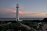
Point Lowly
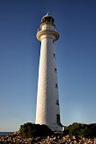
The height of Point Lowly tower was increased in 1909
|
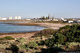
Point Lowly marks the entrance to the narrow basin of upper Spencer Gulf. Wind generated waves dominate the upper Spencer Gulf coastline which is protected from the ocean swell. The area has regular dodge tides every fortnight. During a dodge tide there is no tidal movement for a period of a day or two. This phenomenon is experienced in only a few other locations in the world.
Gulf St Vincent, Torres Strait and Gulf of California.
|
|
Mathew Flinders explored the gulf in 1802. March 9, 1802 "at noon, the furthest hummock seen from the anchorage was distant four or five miles; it stands on a projection of low sandy land, and beyond it was another similar projection to which I gave the name of Point Lowly"
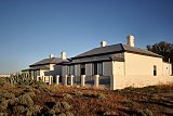
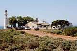
The lighthouse and two cottages were completed in 1883. from materials transported by sea from Port Pirie or the rough coastal road from Port Augusta. The city of Whyalla (30km away) did not exist at the time.
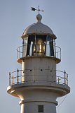
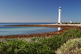
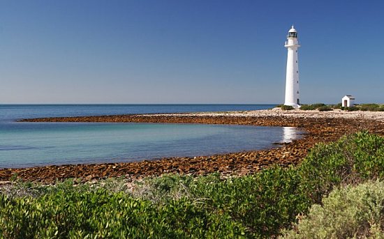
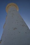
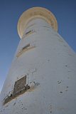
The original lighthouse was a 15 metres high sandstone tower with the optical apparatus imported from Chance Bros. England. It was first lit on 1 February 1883. After several incidents north of Point Lowly, the tower was extended to its current height of 22.8 metres in 1909.
The light is now a 1000-watt lamp powered by mains, with a standby generator. The light gives one flash every 5 seconds and has a range of 26 nautical miles (48
kms).
|
Two resident lightkeepers manned the lighthouse for 90 years until January 1973 when it was automated. In
February 1993 it was turned off by the Australian Maritime Safety Authority AMSA as it believed the lighthouse was no longer required. The Whyalla City Council purchased the lighthouse with the help of the SA Government, and it was re-lit in March 1995.
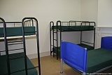
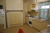
The Whyalla Uniting Church has managed the cottages for community and recreational purposes since 1979. The cottages sleep up to 30 people, are basic but clean, with good kitchen facilities. Accommodation enquiries Ph: 08 8645 0436 between 10am and 1pm daily.
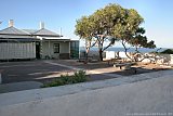
Port Bonython, just west of Point Lowly, processes liquid hydrocarbons. The mixture of
crude oil and natural gas liquids is pumped through a 659km long pipeline from
Moomba. The mixture is processed separating the liquids into crude oil, naphtha and LPG.
Servicing 50 ships a year is a jetty, 2400 metres long, was completed in 1984.
|
|
|
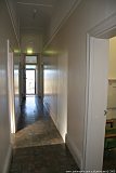
The lighthouse cottages are clean and facilities are very modern. Beds are very
basic, but plentiful. So many to choose from when it was just me staying there! |
 |
 |
 |
 |
 |
|
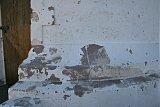
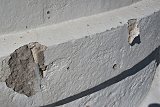
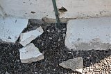
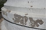
These photos taken in December 2004, show a tower that is need of much repair.
Paintwork is peeling off and in some places the stonework is coming away with
the paint. The lower window ledge has crumbled away. The lantern-room is showing
signs of rust. The tower was last painted just prior to the hand over to the
council. Maintenance problems like this are fast becoming the biggest threat to
out lighthouse preservation. |
 |
 |
 |
 |
 |
 |
|
|
|
| Technical / Historical Details |
| Nearest Town | Whyalla | Height - Elevation | 25.0m (82ft) - 22.9m (75ft) |
| Lat/Long: | 33°00.1'S 137°47.1'E | Lantern | |
| Construction | White round stone tower | Lens | 3rd order |
| Built | 1883 | Character | Fl.W. period 5s |
| First Lit | 1/02/1883 | Range NM | 26W |
| Automated | 1973 | | |
| De-activated | | Open | Grounds only |
| Architect | | Access | Road |
| Reference | 8524 K 1948 | Accommodation | Yes |
| Sources: | Personal visit |
| Other Links: | | |